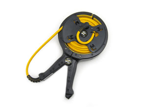
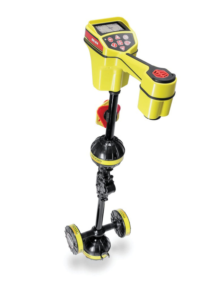
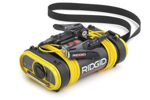
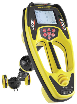
{"id":2521610092628,"title":"SR-24 Line Locator with Bluetooth® and GPS","handle":"sr-24-line-locator-with-bluetooth®-and-gps","description":"\u003cp\u003e\u003cstrong\u003eSR-24 Line Locator with Bluetooth® and GPS (includes case)\u003c\/strong\u003e\u003c\/p\u003e\n\u003cp\u003e\u003cstrong\u003eThe SR-24 is a precision utility locating instrument with GPS and Bluetooth® technology for easy integration with external data capture devices.\u003c\/strong\u003e\u003c\/p\u003e\n\u003cp\u003eThe SR-24’s omnidirectional antennas capture the complete signal field, making it easy to acquire the signal and trace its path. The receiver displays the utility's position and direction on the display, providing an intuitive locating experience. For added confidence, audio and visual warnings notify the operator if the shape of the signal field is being distorted so that appropriate action can be taken to avoid mismarking the utility’s position.\u003c\/p\u003e\n\u003ch4\u003eFeatures\u003c\/h4\u003e\n\u003cul\u003e\n\u003cli\u003eLarge Display - shows the utility’s estimated position, direction, and depth.\u003c\/li\u003e\n\u003cli\u003eOmnidirectional Antennas - capture the complete signal field for greater speed and accuracy.\u003c\/li\u003e\n\u003cli\u003eBuilt-In GPS - track location coordinates for mapping and GIS applications.\u003c\/li\u003e\n\u003cli\u003eBluetooth Technology - stream data to smartphones, tablets, or high-precision GPS instruments.\u003c\/li\u003e\n\u003cli\u003eSmartphone\/Tablet App - map multiple tracks and waypoints and export to GIS software.\u003c\/li\u003e\n\u003cli\u003eCan trace any frequency from 10 Hz to 35 kHz.\u003c\/li\u003e\n\u003c\/ul\u003e\n\u003cp\u003e\u003cbr\u003e\u003cstrong\u003eRIDGIDtrax\u003c\/strong\u003e\u003c\/p\u003e\n\u003cp\u003eRIDGIDtrax enables basic underground utility mapping in real time. Connect an Android or iOS device wirelessly to a RIDGID® SR-24 Utility Locator and RIDGIDtrax will display GPS position and depth of the target utility. Identify the type of utility (water, gas, electric, etc.) and display multiple utilities on the same map. A finished map can be saved and viewed inside the app or exported to a *.KMZ file for use with popular GIS programs such as Google Earth®.\u003c\/p\u003e\n\u003ch4\u003eSpecifications\u003c\/h4\u003e\n\u003cul\u003e\n\u003cli\u003e\n\u003cstrong\u003eActive Line Trace Frequencies*\u003c\/strong\u003e 128 Hz, 1 kHz, 8 kHz and 33 kHz\u003c\/li\u003e\n\u003cli\u003e\n\u003cstrong\u003ePassive Power Trace\u003c\/strong\u003e 50 Hz, 60 Hz, \u0026lt;4 kHz Broadband\u003c\/li\u003e\n\u003cli\u003e\n\u003cstrong\u003ePassive Radio Trace\u003c\/strong\u003e 4 kHz-15 kHz, 15 kHz-36 kHz\u003c\/li\u003e\n\u003cli\u003e\n\u003cstrong\u003eSonde Frequencies *\u003c\/strong\u003e 16 Hz, 512 Hz, 640 Hz, 850 Hz, 8 kHz, 16 kHz, 33 kHz\u003c\/li\u003e\n\u003cli\u003e\n\u003cstrong\u003ePower Source\u003c\/strong\u003e 4 C-Cell batteries (included).\u003c\/li\u003e\n\u003cli\u003e\n\u003cstrong\u003eBattery Life\u003c\/strong\u003e Approximately 16 hours\u003c\/li\u003e\n\u003cli\u003e\n\u003cstrong\u003eWeight\u003c\/strong\u003e 3.5 lbs. (1.6 kg)\u003c\/li\u003e\n\u003cli\u003e\n\u003cstrong\u003eWireless Technology\u003c\/strong\u003e Bluetooth Class 1\u003c\/li\u003e\n\u003cli\u003e\n\u003cstrong\u003eWireless Range\u003c\/strong\u003e 200 yards (183 meters)\u003c\/li\u003e\n\u003cli\u003e\n\u003cstrong\u003eGPS Average Accuracy\u003c\/strong\u003e Less than 8.2’ (2.5 m)\u003c\/li\u003e\n\u003c\/ul\u003e","published_at":"2019-03-19T17:44:08-07:00","created_at":"2019-03-19T17:44:08-07:00","vendor":"RIDGID","type":"Diagnostics, Inspection \u0026 Locating","tags":["Utility Locating"],"price":285600,"price_min":285600,"price_max":285600,"available":false,"price_varies":false,"compare_at_price":null,"compare_at_price_min":0,"compare_at_price_max":0,"compare_at_price_varies":false,"variants":[{"id":22010002899028,"title":"Default Title","option1":"Default Title","option2":null,"option3":null,"sku":"44473","requires_shipping":true,"taxable":true,"featured_image":null,"available":false,"name":"SR-24 Line Locator with Bluetooth® and GPS","public_title":null,"options":["Default Title"],"price":285600,"weight":7257,"compare_at_price":null,"inventory_management":"shopify","barcode":"","requires_selling_plan":false,"selling_plan_allocations":[]}],"images":["\/\/tradetoolsupply.com\/cdn\/shop\/products\/sr24_beauty_72dpi_lowres_7.jpg?v=1553042721"],"featured_image":"\/\/tradetoolsupply.com\/cdn\/shop\/products\/sr24_beauty_72dpi_lowres_7.jpg?v=1553042721","options":["Title"],"media":[{"alt":null,"id":1431138205780,"position":1,"preview_image":{"aspect_ratio":0.75,"height":1000,"width":750,"src":"\/\/tradetoolsupply.com\/cdn\/shop\/products\/sr24_beauty_72dpi_lowres_7.jpg?v=1553042721"},"aspect_ratio":0.75,"height":1000,"media_type":"image","src":"\/\/tradetoolsupply.com\/cdn\/shop\/products\/sr24_beauty_72dpi_lowres_7.jpg?v=1553042721","width":750}],"requires_selling_plan":false,"selling_plan_groups":[],"content":"\u003cp\u003e\u003cstrong\u003eSR-24 Line Locator with Bluetooth® and GPS (includes case)\u003c\/strong\u003e\u003c\/p\u003e\n\u003cp\u003e\u003cstrong\u003eThe SR-24 is a precision utility locating instrument with GPS and Bluetooth® technology for easy integration with external data capture devices.\u003c\/strong\u003e\u003c\/p\u003e\n\u003cp\u003eThe SR-24’s omnidirectional antennas capture the complete signal field, making it easy to acquire the signal and trace its path. The receiver displays the utility's position and direction on the display, providing an intuitive locating experience. For added confidence, audio and visual warnings notify the operator if the shape of the signal field is being distorted so that appropriate action can be taken to avoid mismarking the utility’s position.\u003c\/p\u003e\n\u003ch4\u003eFeatures\u003c\/h4\u003e\n\u003cul\u003e\n\u003cli\u003eLarge Display - shows the utility’s estimated position, direction, and depth.\u003c\/li\u003e\n\u003cli\u003eOmnidirectional Antennas - capture the complete signal field for greater speed and accuracy.\u003c\/li\u003e\n\u003cli\u003eBuilt-In GPS - track location coordinates for mapping and GIS applications.\u003c\/li\u003e\n\u003cli\u003eBluetooth Technology - stream data to smartphones, tablets, or high-precision GPS instruments.\u003c\/li\u003e\n\u003cli\u003eSmartphone\/Tablet App - map multiple tracks and waypoints and export to GIS software.\u003c\/li\u003e\n\u003cli\u003eCan trace any frequency from 10 Hz to 35 kHz.\u003c\/li\u003e\n\u003c\/ul\u003e\n\u003cp\u003e\u003cbr\u003e\u003cstrong\u003eRIDGIDtrax\u003c\/strong\u003e\u003c\/p\u003e\n\u003cp\u003eRIDGIDtrax enables basic underground utility mapping in real time. Connect an Android or iOS device wirelessly to a RIDGID® SR-24 Utility Locator and RIDGIDtrax will display GPS position and depth of the target utility. Identify the type of utility (water, gas, electric, etc.) and display multiple utilities on the same map. A finished map can be saved and viewed inside the app or exported to a *.KMZ file for use with popular GIS programs such as Google Earth®.\u003c\/p\u003e\n\u003ch4\u003eSpecifications\u003c\/h4\u003e\n\u003cul\u003e\n\u003cli\u003e\n\u003cstrong\u003eActive Line Trace Frequencies*\u003c\/strong\u003e 128 Hz, 1 kHz, 8 kHz and 33 kHz\u003c\/li\u003e\n\u003cli\u003e\n\u003cstrong\u003ePassive Power Trace\u003c\/strong\u003e 50 Hz, 60 Hz, \u0026lt;4 kHz Broadband\u003c\/li\u003e\n\u003cli\u003e\n\u003cstrong\u003ePassive Radio Trace\u003c\/strong\u003e 4 kHz-15 kHz, 15 kHz-36 kHz\u003c\/li\u003e\n\u003cli\u003e\n\u003cstrong\u003eSonde Frequencies *\u003c\/strong\u003e 16 Hz, 512 Hz, 640 Hz, 850 Hz, 8 kHz, 16 kHz, 33 kHz\u003c\/li\u003e\n\u003cli\u003e\n\u003cstrong\u003ePower Source\u003c\/strong\u003e 4 C-Cell batteries (included).\u003c\/li\u003e\n\u003cli\u003e\n\u003cstrong\u003eBattery Life\u003c\/strong\u003e Approximately 16 hours\u003c\/li\u003e\n\u003cli\u003e\n\u003cstrong\u003eWeight\u003c\/strong\u003e 3.5 lbs. (1.6 kg)\u003c\/li\u003e\n\u003cli\u003e\n\u003cstrong\u003eWireless Technology\u003c\/strong\u003e Bluetooth Class 1\u003c\/li\u003e\n\u003cli\u003e\n\u003cstrong\u003eWireless Range\u003c\/strong\u003e 200 yards (183 meters)\u003c\/li\u003e\n\u003cli\u003e\n\u003cstrong\u003eGPS Average Accuracy\u003c\/strong\u003e Less than 8.2’ (2.5 m)\u003c\/li\u003e\n\u003c\/ul\u003e"}
SR-24 Line Locator with Bluetooth® and GPS

Related Products
Call for Pricing
Call for Pricing
Call for Pricing
Call for Pricing
Call for Pricing
Call for Pricing
Call for Pricing